BWSR Living Landscapes Initiative
Why
Many impacts such as climate change, habitat loss, invasive species, pesticides, and disease are influencing the resiliency of landscapes and leading to the loss of plant and animal populations. The decline of wildlife including beneficial insects (pollinators, butterflies, dragonflies, etc.), birds, amphibians and other species, is a significant concern for conservation professionals and residents of Minnesota. These species provide a foundation for food production, food webs and native ecosystems. Their loss results from a variety of factors including habitat loss, invasive species, pesticides, climate change, and diseases.
Goals
- Increase awareness about declining wildlife and plant populations and build a movement to address these challenges in collaboration with partners and Minnesota residents
- Build habitat corridors and structure across all types of Minnesota landscapes
- Engage diverse communities and the next generation of conservationists
- Focus on the biological health of landscapes to meet soil health and water quality goals
- Support pollinators that sustain our food production and ecosystems
- Build landscape resiliency
Scope and Approach
The Living Landscapes Initiative is focused on supporting at-risk wildlife species, establishing habitat corridors, and building landscape resiliency through collaboration with conservation partners and Minnesota residents. Program goals are being met through a combination of project funding, outreach, education and technical assistance to partners and residents.
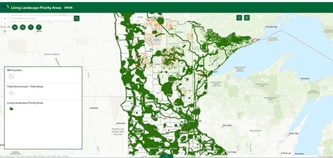
BWSR Living Landscape Map
The BWSR Living Landscape map was created to guide BWSR efforts to protect at-risk wildlife, increase landscape resiliency, and expand habitat corridors along waterways, roads and utility corridors. The purpose of the data is to guide decision making for the BWSR Living Landscapes Initiative including project selection for individual conservation programs. The data will be updated periodically to add new habitat corridors that are being developed across the state. If you would like to propose revisions to the Living Landscape map refer to the submission requirements. The data can also be downloaded at the Minnesota Geospatial Commons.
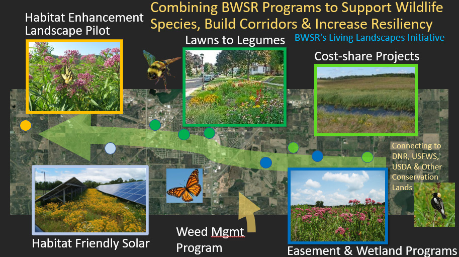
Related BWSR Programs
Lawns to Legumes Program (residential landscape focused pollinator program)
Habitat Friendly Solar Program (recognizes habitat as part of grounded-mounted solar projects)
Habitat Friendly Utilities Program (collaboration with utility companies to incorporate habitat into a wide range of projects)
Habitat Enhancement Landscape Pilot (HELP) (strategic habitat on conservation lands and natural areas for pollinators and a wide range of beneficial insects)
Conservation Easements (restored prairie, wetland, forest and shoreline easements)
Clean Water Fund Projects (habitat is a secondary benefit of water quality projects)
Wetland Mitigation/Banking (high quality restored wetlands and buffers)
Cooperative Weed Management Area Program (partnerships to share resources and manage invasive species across ownership boundaries)
Partners
For more information contact: Dan Shaw at Dan.Shaw@state.mn.us.
Living Landscapes Initiative Resources
- Seed Mix Webpage (Includes 70 state seed mixes and fact sheets)
- Pollinator and Biodiversity Toolbox (Guidance for pollinator projects)
- What’s Working Website (Successful conservation projects summarized by conservation professionals)
- BWSR Native Vegetation Establishment and Enhancement Guidelines
- Featured Plant Articles (Native plants important for conservation efforts)
- Technical Guidance Documents (Upland and wetland restoration strategies)
- Minnesota Wetland Restoration Guide (Comprehensive wetland restoration guidance)
- Climate Resiliency Toolbox (Strategies for climate adaptation and mitigation)
- Buffer Establishment and Enhancement Toolbox (Buffer restoration planning)
- Lawns to Legumes Program
- FAQs (pdf)
- 2026 BWSR Pollinator Plan (pdf)
- Protecting Minnesota's Pollinators Brochure (pdf)
- Protecting Conservation Plantings from Pesticides (pdf)
- Shorebird Conservation Report (pdf)