Below are statewide and program-specific geospatial resources related to RIM programs. This list includes shapefiles needed in order to submit RIM applications and complete scoresheets for each program.
RIM Interactive Map
The RIM Interactive Map displays existing easement boundaries and lists eligible RIM programs for locations after they are manually selected. There is a search by address and township/section/range feature within the map tool. A static PDF map of RIM easements may be found here (Updated June 2025).
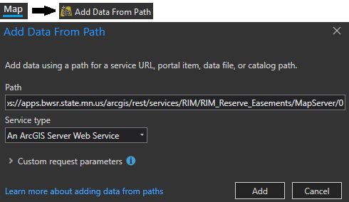
ArcGIS Web Service Layer
Add state-funded conservation easement boundaries via a web service layer in ArcGIS Pro:
Resources for all RIM Easement Program Applications
- Minnesota Geospatial Commons
- RIM Easement Programs – Interactive Map
- Public Waters (PW) Basin and Watercourse Delineations
- Buffer Protection Map
- Mapping Tool : Minnesota Natural Resource Atlas (mnatlas.org)
- MnTOPO – High-resolution elevation data
- Historic Aerial Photos
Permanently Protected Lands
- RIM Public Boundaries (exclude limited duration and expired easements)
- State Administered Lands – DNR Management Units
- NRCS Easements
- USFWS Shapefiles & USFWS – National Realty Tracts
Program-Specific Shapefiles
Eligibility Areas for Non-Statewide RIM Programs
- BWSR Easement Programs (pdf) 1/12/2026
- ACUB (zip)
- CREP (zip)
- Pine & Leech Watershed Shoreland Protection (zip)
- RIM Critical Shorelands (zip)
- RIM Reforestation (zip)
- Wild Rice (zip)
1W1P
CREP
- Additional Wildlife Benefits (zip)
- MN Prairie Plan Core and Corridors (zip)
- Drinking Water Management Supply Area (DWSMA) Vulnerability
- Wellhead Protection Areas
- MN Wildlife Action Plan (WAN) Layer
- Minnesota Biological Survey (MBS) Sites of Biodiversity Significance
- LSOHC Planning Sections
- USDA Forest Service Forest to Faucets Important Watersheds for Surface Drinking Water Index
- Vulnerable Groundwater Areas (Coarse Texture Soils & Karst)
- Drinking Water Management Supply Area (DWSMA) Vulnerability ("High" or "Very High")
- Wellhead Protection Areas
Grasslands
- MNDNR Native Plant Communities
- MNDNR Native Prairies
- MN Prairie Conservation Plan Core and Corridors (zip)
- Potentially Undisturbed Land
RIM Grazing
- Additional Wildlife Benefits (zip)
- Drinking Water Supply Management Area Vulnerability
- MN Important Bird Areas
- MN Wildlife Action Plan WAN Layer
- Total Maximum Daily Load (TMDL) and Watershed Restoration and Protection Strategy (WRAPS) Project Boundaries
Riparian & Floodplains
Wetlands & Peatlands
- RIM Wetlands Additional Wildlife Benefits (zip)
- Potentially Restorable Peatlands Mapping Tool
- MN Prairie Conservation Plan Core and Corridors (zip)
- Minnesota Biological Survey Sites of Biodiversity Significance
- Additional resources to help identify restorable wetlands: