What's Working for Conservation
Site Selection
2020 Information
Stearns County SWCD Shoreline Project Process:
The Stearns County SWCD has implemented a series of standards to ensure success for shoreline stabilization projects. This includes guidelines for site selection, design considerations, funding, board approval, long term operation and maintenance, monitoring and protection. The following are steps taken:
Site Selection – Sites are selected based on considerations of current stabilization conditions, protection, habitat connections, water quality benefits and landowner motivation. In general, all of these criteria need to be met for a project to be deemed worthy of a shoreline conservation practice.
Design Considerations - The SWCD uses a policy for all shoreline projects that requires a native buffer is in existence or planted as part of an approved Stearns County SWCD plan. The native buffer on the property shall require at least 75% of the shoreline length, with a maximum traffic (water access) area of no more than 25 feet along the shoreline. Properties in public and commercial ownership can be given exception to this policy to have a larger water access but will have to adhere to having a 75% buffer of native vegetation on the length of shoreline owned. Public and commercial properties will have to provide a needs and suitability request for a larger traffic area to the SWCD Board. Traffic area is defined as any area not containing a majority of native vegetation, ie: mowed grass, areas with retaining walls, steps, paths, buildings, other topographic alterations or manmade structures. The existing and new buffer areas shall extend at least 25 feet landward of the Ordinary High Water Level of the lake/river or to the top of the nearest slope (12% steepness or more) whichever is greater. This shall be applied to the watercourse of all properties where projects are proposed and implemented. If shoreline erosion control is needed, the SWCD considers a group of bio-engineering practices depending on the lake, water fluctuations, watershed characteristics, site conditions, elevations, and landowner needs. Some of the more common bio-engineering practices used are Cedar Tree Revetments, Coir Logs, Footer Logs, Footer Rock, Live Stakes, and Brush Bundles. Rock Riprap is a design alternative considered when other methods are not feasible. A critical part of the design process is to bring in experts in the field from DNR, BWSR, Watershed Districts, Technical Service Areas, private consultants, and other SWCD staff.
Funding – In general the SWCD makes an effort to fund projects with 75% cost share. The funding for these projects is obtained from a variety of state, federal and private sources.
Board Approval – Once the final design is complete, the landowner is required to get a minimum of two contractor estimates if hiring the work to be completed. If the landowner is proposing to complete the work on their own, they develop an estimate. The SWCD Board bases the cost share approval off the lowest estimate and encumbers the funds. A letter is sent to the landowner documenting the project details and projected funding. Once the project is finished, a Payment Voucher/Practice Certification Voucher form is completed to go along with the invoice submitted. The SWCD Board will use this to make final payment.
Operation and Maintenance – An Operation and Maintenance Plan is developed by the SWCD and signed by the landowner as well as the
SWCD project technician. This outlines the conservation practice(s) installed and lists items for the landowners to check on as well as maintain. As a part of this process, the SWCD completes Status Review site visits and associated documentation in years 1, 5 and 9 following the completion of the projects. In addition, periodic project reviews are completed after these timeframes. This is part of the ongoing relationship with the landowner and for SWCD staff to learn from the project implementation.
Monitoring – The SWCD uses various pollution reduction calculators to determine the water quality benefits of each project. The BWSR Pollution Reduction Calculator is most commonly used. Where feasible the SWCD also uses water quality monitoring to determine the improvements related to projects implemented. In addition, the SWCD makes an effort to quantify other benefits of shoreline projects related natural aesthetics, reduced flooding, as well as habitat improvements and connections.
Protection – The Stearns County SWCD developed a process for long term protection of shoreline projects. This is accomplished by recording a Shoreline Deed Restriction on the property that includes the following: as-built plans, full legal description, operation and maintenance plan, planting plan and cost share contract. This perpetual agreement is required on all new shoreline projects with the SWCD. It can also be used to protect natural shorelines in the County that follow the SWCD policies. If any future adjustments are proposed to the deed restriction an SWCD staff member works with the landowner and SWCD Board to adhere to the policies and guidelines established. The SWCD has also developed a process with the County Land Management Department to notify landowners that a Shoreline Project Deed Restriction exists when properties change ownership.
(Greg Berg, Riparian Resources Specialist, Stearns SWCD)
2013-2014 Information
Waterfowl Considerations: When working to add habitat to existing complexes for waterfowl it is important to do so with an eye to what may be missing or in short supply. There must be permanent wetlands of high enough quality to provide food for migrating, molting, and brooding ducks. There must also be sufficient nesting cover, a few hundred acres of grassland may be enough to attract nesting hens, but more grassland, and in larger blocks is the key to decrease edge and help ensure nest success. Also focus on adding temporary and seasonal wetlands to build breeding pairs once adequate nesting habitat is available, as these additional basins can be critically important for broods and migration as well (Ray Norrgard, MDNR).
Prioritizing Wetlands: A “Restorable Wetland Prioritization Tool” developed by the Minnesota Natural Resources Research Institute in partnership with the Minnesota Pollution Control Agency is now available. This tool will aid individuals interested in wetland restoration or protection by:
- Predicting likely locations of restorable wetlands with a statewide restorable wetland inventory.
- Locating highly stressed areas most in need of water quality or habitat improvement.
- Prioritizing areas that already are or are most likely to result in high functioning sustainable wetlands.
- Identifying areas that will provide the greatest benefits in the form of water quality and habitat.
- Refining prioritizations with aerial imagery and available environmental data.
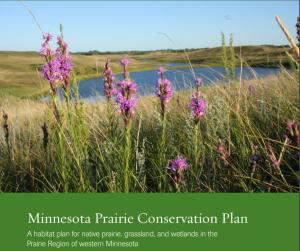
Use of Plans for Site Selection: The Minnesota Prairie Conservation Plan (pdf) focuses on the restoration of prairie and wetland plant communities through coordination between federal agencies, state agencies and conservation organizations. The plan identifies core conservation areas and creates a vision of a connected landscape from Canada to Iowa.
2008-2012 Information
Site Investigations: We perform a thorough pre-application site investigation of all potential wetland restoration projects; including drainage investigations such as tile location, flow direction, size of intake(s), elevations, private and public systems etc. Part of the pre-application process is reviewing the site with a landowner. Good communication with the landowner and the neighboring landowner from the get-go prevents mistakes in the design and construction stage (Renville SWCD).
Site Prioritization: When assessing funding priorities, Roadsides for Wildlife considers the following questions: which sites will provide the best grassland bird habitat (larger projects are usually better and our prime target area is within the pheasant range), which sites are publicly owned and likely to remain as long term investments, at which sites will road construction be completed within the funding cycle, and which applicants are likely to do follow-up maintenance (DNR Roadsides for Wildlife Program).
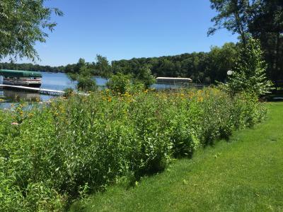
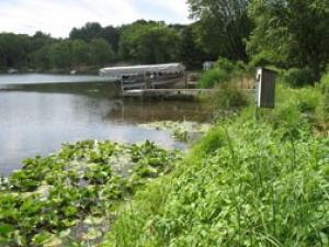
Shoreline Study: Typically all sites come to us with erosion or stormwater issues. Doing a shoreline study helped us create a very good plan highlighting areas of erosion on McCarrons and Long Lake. This helped us target areas that we want to put money into to improve water quality (see photo - Ramsey Conservation District).
Subwatershed Assessment: The Metro Conservation District’s Landscape Restoration Program subwatershed stormwater analysis is a rapid, relative investigation that identifies ideal locations of specific stormwater best management practices within the landscape. The analysis is performed on at least three levels of resolution that selects which subwatershed to address, which catchments within the subwatershed to work within and, finally, which sites within the catchments to site specific BMP’s. Results of the study are expressed in terms of BMP life-cycle unit costs per pound of pollutant removed, or similar, in a report. This report identifies a list of “low-hanging fruit”, essentially which catchments (and their specific sites) to focus initial stormwater work in. It considers the performance of any existing stormwater water quality treatment and conveyance infrastructure along with site-specific limiting effects on the placement, or modification of in-situ BMP’s, of a myriad of BMP options within ponding, filtering and infiltrating designs. Estimates on existing annual loading, existing treatment efficacy and three levels of treatment are reported enabling the Local Governing Unit to plan for several years of retrofit options. This analysis is powerful in its ability to identify the highest value options for stormwater treatment within a subwatershed in terms of cost efficiency and its value towards various other planning efforts such as load allocation planning, capitol improvement and aesthetic-amenity planning within cities. P8 and WinSLAMM are models that are used for this effort. To see further examples and background, the MCD website has a Subwatershed Assessments page. Along with the Anoka Conservation District website that provides completed Subwatershed Stormwater Retrofit Analysis Reports.
(Shawn Tracy, Association of Metropolitan Soil and Water Conservation Districts).
Site Assessment Considerations: Each site is custom designed based on local ecotype, availability of seed, surrounding landuse, soil/moisture/aspect/slope, needs of the landowner, and cost. Salt tolerance and need for living snow fence are also considered where appropriate (DNR Roadsides for Wildlife Program).
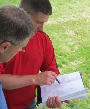
Landowner Meetings: We meet with the owners and discuss what we are going to draw up for them. Keeping plans very detailed for easy reading (homeowners and contractors can bid off them). We use plants native to Minnesota (see photo). We highly recommend doing great prep work and not just the minimum (Ramsey SWCD).
Wildlife Needs: When planning a project it is important to consider the needs of wildlife species and how vegetation will influence their use. Grassland birds for example tend to have unique needs related to community structure. The following website is a good source of information about the requirements of wildlife species: www.npwrc.usgs.gov/resource/birds/wiscbird/.
Anticipating Impacts: Sufficient planning needs to be done to anticipate potential impact to a project from animals (carp, geese, muskrat, deer) or human use (Shawn Tracy, Association of Metropolitan Soil and Water Conservation Districts).
Site Stressors: A clear understanding of site stressors is needed to determine how project phasing should be conducted and what plant species are most appropriate for a project
(Shawn Tracy, Association of Metropolitan Soil and Water Conservation Districts).
Project Schedules: Developing detailed project schedules for wetland projects has been very useful to ensure that all contractors and project staff understand the proposed process. Including project maintenance (for at least 3-years) as part of project plans is essential; when there is no commitment to maintenance projects often fail.
Maintenance Requirements: It is important to consider maintenance requirements when selecting plant diversity levels. Increasing cool-season grasses and forbs can often decrease invasive species. Grass only mixes may allow for use of broad leaf specific herbicides but may be prone to Canada thistle invasion.
Qualified Contractors: Whenever possible it is important to have qualified contractors conduct all phases of the projects (site preparation, planting, maintenance).
Combining Planting Strategies: It is often important to combine different planting strategies for wetland projects (Seed, pre-vegetated mats, containerized plants, native seedbank, etc.). For example, seed may be used for vegetating the majority of a wetland project but containerized emergent plants or pre-vegetated mats may be used along the edge of open water to ensure establishment where hydrology levels are variable, and wave action may exist.
Conservation Funding Guide: The online Conservation Funding Guide is a useful resource to help landowners and assistance providers search different conservation funding programs and determine the best program to fix a resource problem. The "compare payments" hyperlink allows users to see different programs, payment rates, and incentives that particular program have to offer: www.mda.state.mn.us/protecting/conservation/funding.htm