
Top Bar
  • About
  • Careers
  • Contact
  • About
  • Careers
  • Contact
Search Area
    • About BWSR Grants
      • Apply for BWSR Grants
      • Frequently Used Acronyms
      • Grant Information & Resources
      • Grants Quarterly Newsletter
    • Resources for Grantees
      • eLINK
      • Grants Administration Manual
      • Landscape Resiliency & Climate Change
        • Alliance to Advance Climate-Smart Agriculture
        • BWSR Climate Resiliency Toolbox
        • Carbon Sequestration: Conservation Practices and Programs
      • What’s Working for Conservation
      • Vegetation Establishment & Management
        • Native Vegetation and Biodiversity Collaborative
        • Native Vegetation Establishment and Enhancement Guidelines
        • Seed Mixes
        • Native Plant ID and Information
      • Restoring Conservation Lands
      • Overview
      • Programs
      • Easement Forms
      • RIM Handbook & Guidance
      • Existing Easements
      • SWCD Resources
        • Contacts
        • RIM Interactive Map
        • Geospatial Resources
        • Conservation Lands by County
        • Online Learning
        • RIM Rundown
        • Easement Alteration Policy
      • Living Landscapes Initiative
        • Lawns to Legumes: Your Yard Can BEE the Change
        • Pollinator Pathways Grants
        • Habitat Friendly Utilities Program
        • Habitat Enhancement Landscape Program (HELP)
        • Pollinator and Biodiversity Toolbox
          • Community Outreach
        • Managing Invasives for a Resilient Landscape
        • Minnesota Habitat Friendly Solar Program
        • Community Conservation
      • Lawns to Legumes
      • Pollinator Pathways
      • Habitat Friendly Utilities
        • What to Plant in Buffers
      • Minnesota Buffer Law
      • Buffer Establishment & Management Toolbox
      • Guide to the Buffer Compliance Process
        • Step 1: SWCD Compliance Review
        • Step 2: Landowner Notification
        • Step 3: Notice of Non-Compliance
        • Step 4: Corrective Action Notice Sent
        • Step 5: Issuing Enforcement Action
        • Step 6: Parcel is Compliant
      • Implementation Guidance
        • Average Buffer Widths
        • Buffer Measurement for a Public Drainage Ditch
        • Building Better Buffers
        • Compliance Determinations
        • Conservation Reserve Program Exemption Guidance
        • Determining Normal Water Level
        • Determining the Top or Crown of a Bank for Land Adjacent to a Public Water
        • Haying and Grazing of Buffers
        • Vegetation Establishment Goals
      • Procedures
        • Procedure 1: Compliance Determinations (Parcel and Bank Approach)
        • Procedure 2: Reporting and Progress Tracking
        • Procedure 3: MS4 Exemption
        • Procedure 4: Alternative Practices
        • Procedure 5: Other Alternative Practices Approved by the Board
        • Procedure 6: Local Water Resources Riparian Protection ("Other Watercourses")
        • Procedure 7: Failure to Implement
        • Procedure 8: Election of Jurisdiction
        • Procedure 9: BWSR's Review of County and Watershed District Buffer Rules, Ordinances and Official Controls
      • Alternative Practices
        • Alternative Practices Introduction
        • Common Alternative Practice #1: Minnesota Agricultural Water Quality Certification Program
        • Common Alternative Practice #2: NRCS Filter Strip Standard: MN 393/391 Practice Standards - Public Waters
        • Common Alternative Practice #3: Grassed Waterway/Cultivated Watercourses - Public Waters
        • Common Alternative Practice #4A: Negative Slopes or Concentrated Inflow - Public Ditches
        • Common Alternative Practice #4B: Glacial Lake Plain Areas - Public Ditches
        • Common Alternative Practice #5: Negative Slopes or Concentrated Inflow - Public Waters
        • Common Alternative Practice #6: Conservation Tillage/Cover Crops With Vegetated Filter Strip - Public Waters
        • Decision Support Tool
      • Election of Jurisdiction
      • Enforcement
      • Compliance Tracking Tool (BuffCAT)
      • Buffer Program Update
      • Contacts
      • Soils & Soil Health
        • Model Soil Loss Ordinance
        • Tillage and Erosion Survey Project
        • Soil Health Practices Grant
      • Daily Erosion Project
      • Working Lands Resources
      • Agricultural Lands
      • Forest Land
      • Peatlands
      • One Watershed, One Plan
        • One Watershed, One Plan Participating Watersheds
        • One Watershed, One Plan Policies
        • One Watershed, One Plan Resources
        • One Watershed, One Plan Videos
      • Metro Watershed Management Plan
        • Metro State Agencies Review Roster
        • Metro Update
      • Watershed District Management Plan (non-metro)
        • Amendments and Extensions
        • Development and Revision
      • Metro County Groundwater Plan
      • SWCD Comprehensive Plans
      • Planning Information
      • Working with State Agencies
        • State Agency Review Roster for County Water Plans and Watershed Management Plans
      • Water Storage & Climate Resilience
      • Groundwater Protection
      • Urban Stormwater Management
      • Prioritize, Target, and Measure Application (PTMApp)
      • Water Quality Tools & Models
      • Drainage in Minnesota
        • Understanding Minnesota Public Drainage Law
        • Other Drainage Resources
      • Minnesota Public Drainage Manual
      • Drainage Work Group
      • Drainage Management Team
      • Drainage Records Modernization
      • Chapter 103E Ditch Buffer Strip Reporting
      • Multipurpose Drainage Management
      • Wetlands Regulation in Minnesota
      • Wetland Conservation Act (WCA) Contacts
      • Joint Application Form
      • WCA Forms & Templates
      • WCA Program Guidance & Information
        • WCA Topics of the Week
      • WCA Rulemaking
        • WCA Rulemaking Comments Received
      • WCA Program Reports
      • 404 Assumption
      • Wetland Bank Credits and Fees
      • Wetland Bank Transaction Forms
      • Wetland Bank Guidance and Information
      • Local Government Road Wetland Replacement Program
      • Agricultural Wetland Bank
      • In-Lieu Fee Mitigation Program
      • Wetland Bank & Mitigation Easements
      • Wetland Delineation
      • Wetland Functional Assessment
      • MN Wetland Restoration Guide
      • Minnesota Stream Quantification Tool and Debit Calculator
      • Minnesota Wetland Professional Certification Program Information
      • Wetland Training Schedule and Registration
        • MWPCP Class Portal
      • Wetland Training Resources
      • Online Learning Library & Archive
      • Training Calendar
      • Technical Training and Certification Program
        • Area Technical Training Teams
        • Conservation Planning
        • Core Competency
        • Job Approval Authority
        • Technical Training Individual Development Plan (IDP) Tool
        • Technical Training Resources
      • MN Wetland Professional Certification Program Information
      • BWSR Academy
        • 2026 BWSR Academy
        • 2025 BWSR Academy
        • 2024 BWSR Academy
      • BWSR Spring Training
      • Training Updates
      • Successful Outreach Strategies
      • Performance Review and Assistance Program (PRAP) Grants
        • PRAP Grants
        • Conservation Project Planning and Promotion
          • Inspections
        • Invasive Species Control
        • Native Vegetation
        • Pollinator Habitat
        • Prairie, Savanna, Forest and Agricultural Projects
        • Stormwater, Shoreline and Wetland Projects
      • Standard Reviews & Checklists
        • FY25 Conservation Reserve Program State Incentives Grant Program
      • PRAP Legislative Reports
    • About BWSR
      • What We Do
      • Board
      • BWSR Executive Leadership
      • Staff
      • Strategic Plan
        • Engagement Process
      • Diversity, Equity and Inclusion
      • Affirmative Action Plan
      • Legislative Resources
      • Careers
      • Contact Us
    • About Our Partners
      • Soil and Water Conservation Districts
      • Watershed Districts
      • Watershed Management Organizations
      • Counties
      • Cities and Townships
      • Regional Partnerships
    • News & Publications
      • Subscribe
      • News Releases
      • BWSR Story Library
      • Conservation Stories
      • BWSR Snapshots
        • Snapshots Archive
      • Featured Plant
        • Featured Plant Archive
      • Reports

Search

  1. Home
  2. Search

February 2022 Featured Plant: Bebb's willow

Peter Yang

Business Number
651-757-2340
First Name
Peter
Last Name
Yang
Email
peter.yang1@state.mn.us
Division
MNIT @ BWSR
Job Title
MNIT - Senior Developer
Business Street
520 Lafayette Road North
Business City
St. Paul
Business State
MN
Business Zip
55155

Clean Water Funds let Stearns SWCD fix more out-of-compliance feedlots

PDF
Media File
StearnsSWCD.ID-v3.pdf
County
Stearns
Major Watershed Basin
Upper Mississippi River Basin
Story Date
Fri, 02/01/2019 - 12:00
Funding Sources
Clean Water Fund
Federal Fund
Publication Type
Conservation Story
Show this story in the slideshow
Off

February 2022 Snapshots

BWSR announces 2018 Outstanding Watershed District Employee

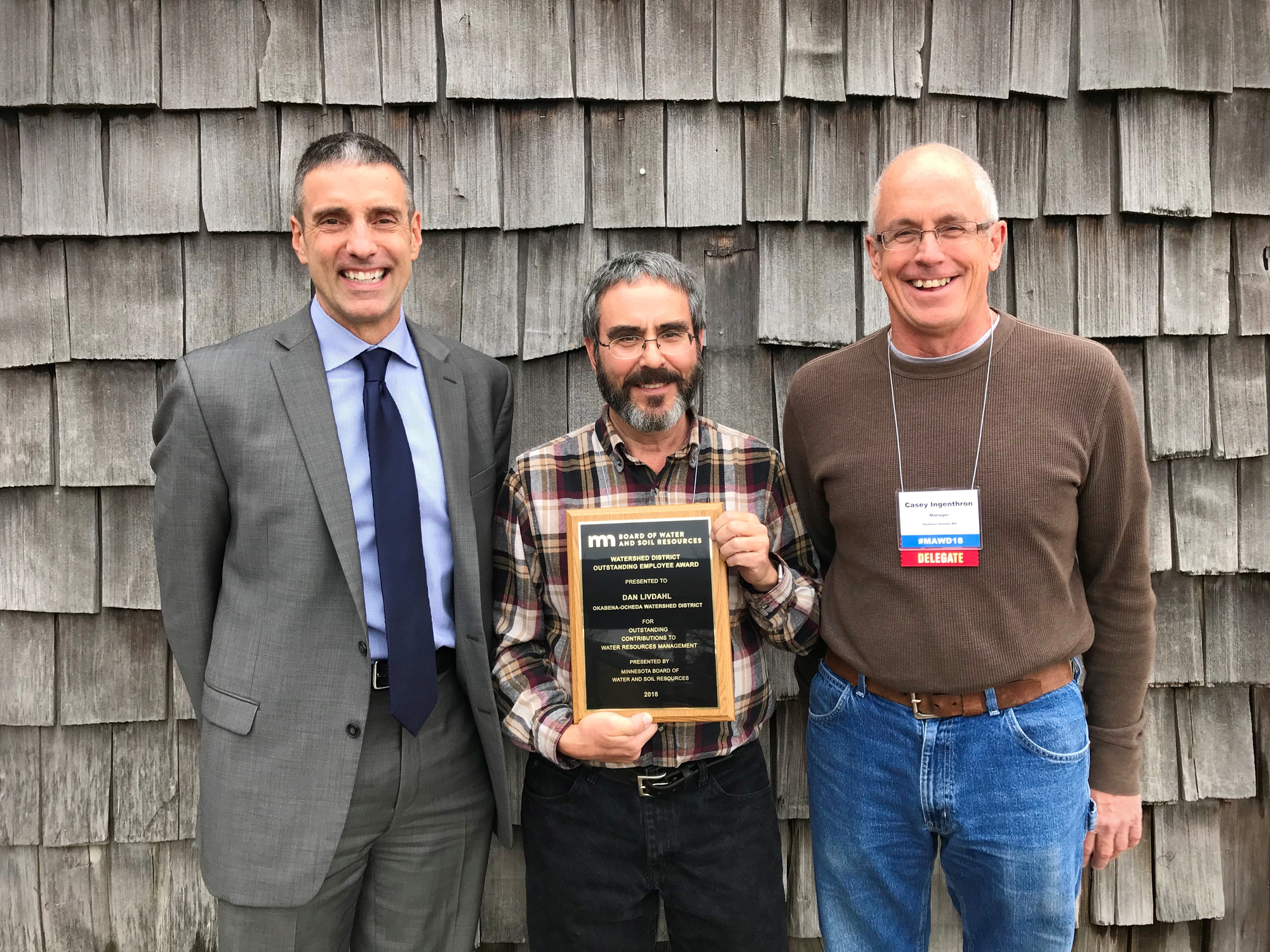
St. Paul, Minn.—Minnesota Board of Water and Soil Resources (BWSR) Executive Director John Jaschke presented the 2018 Outstanding Watershed District Employee award on Friday, Nov. 30 to Okabena-Ocheda Watershed District Administrator Dan Livdahl. The recognition ceremony took place during the Minnesota Association of Watershed Districts’ (MAWD) annual conference in Alexandria.

“Local partners are the driving force behind successful water quality improvement projects,” Jaschke said. “Dan Livdahl’s commitment to preserving our water resources is commendable, and we appreciate all he does to further conservation efforts in Southwest Minnesota.”

Livdahl is the sole employee of the watershed district, where his primary duties involve groundwater and surface water protection efforts. His achievements are proof that a small office can accomplish big goals: In 2016, he helped secure a $428,000 Clean Water Legacy Projects and Practices grant to construct in-stream phosphorus treatment filtration structures on a retired golf course owned by the city of Worthington. Livdahl also coordinates with collaborating agencies, monitors flood prevention structures, and conducts public outreach efforts to increase support for water quality improvement initiatives throughout the southwest region.

In addition to his work for the watershed district, Livdahl is the lead member and coordinator of the Missouri River Watershed One Watershed, One Plan planning effort. He also serves as chair of the Prairie Ecology Bus Center Board of Directors, a non-profit that provides a mobile nature center and ecology lab to residents of southwest Minnesota.

Each year, BWSR celebrates the excellent work accomplished by local government staff to advance conservation efforts across the state. An award for Outstanding Soil and Water Conservation District Employee will be presented Dec. 10 at the Minnesota Association of Soil and Water Conservation Districts’ annual conference in Minneapolis.
MAWD

Photo caption: Okabena-Ocheda Watershed District Administrator Dan Livdahl accepted the Watershed District Employee of the Year award from Minnesota Board of Water and Soil Resources Executive Director John Jaschke, left, during the Minnesota Association of Watershed Districts’ annual conference on Nov. 30 in Alexandria. Casey Ingenthron, right, of the watershed district’s board of managers, joined Jaschke in congratulating Livdahl after Friday’s awards presentation. Photo Credit: Ann Wessel, BWSR

Water, wildlife & waterfowl: Clearing up a popular Kandiyohi County lake

PDF
Media File
DiamondLake.MFCRWD.17.pdf
County
Kandiyohi
Major Watershed Basin
Upper Mississippi River Basin
Story Date
Fri, 02/01/2019 - 12:00
Funding Sources
Clean Water Fund
Outdoor Heritage Fund
Publication Type
Conservation Story
Show this story in the slideshow
Off

Three Rivers' Baker Park ravine work aids Lake Independence water quality

PDF
Media File
Pioneer Sarah Creek WMC Lake Independence June 2020.pdf
Video Link
https://www.youtube.com/watch?v=wuyu-kkvwYQ&feature=youtu.be
County
Hennepin
Major Watershed Basin
Upper Mississippi River Basin
Story Date
Wed, 07/01/2020 - 12:00
Funding Sources
Clean Water Fund
Other
Publication Type
Conservation Story
Show this story in the slideshow
Off

Local Governments Collaborate on Water Planning

St. Paul, Minn. – Continuing statewide work to shift local water planning to a more coordinated approach, the Minnesota Board of Water and Soil Resources (BWSR) approved nine new planning grants for the One Watershed, One Plan program. The August 23rd board action allocates up to $2,200,000 in Clean Water Fund grants to fund nine planning projects to address water issues on a watershed basis.

Historically, water resource management has been planned at the county level. County-level planning can pose challenges since water flows according to high and low points on the landscape, not local government boundaries. One Watershed, One Plan aims to align local water planning on watershed boundaries to create prioritized, targeted, and measurable implementation plans. This collaborative approach enables comprehensive water management work on issues like flooding, habitat, water quality, and recreation.

In the One Watershed, One Plan Program, local governments combine information from their existing water plans, data and information from state water agencies, and input from federal agencies, nonprofit organizations, and citizen stakeholders. The resulting plans identify actions that address the largest threats and provide the greatest environmental benefits to high-priority water resources. Key to the process is the partnership between counties, soil and water conservation districts, watershed districts, and other stakeholders to identify and then implement shared priorities and goals.

“One Watershed, One Plan plays a central role in our efforts to accelerate our goals to restore and protect Minnesota’s Waters,” BWSR Executive Director John Jaschke said. “Local governments are responding to the opportunity to come together with their upstream and downstream neighbors, decide what’s most important, and take action for clean water.”

BWSR has divided Minnesota into 63 suggested “planning boundaries,” which are based on major watersheds. The legislature set a participation goal in 2015 of all planning boundaries by the year 2025. So far, the five pilot plans have been approved by the BWSR board and thirteen groups are actively developing plans. These new planning grants bring the number of planning partnerships to 27.

The nine new planning areas are:

  • Hawk Creek watershed, which includes parts of Chippewa, Kandiyohi, and Renville counties.
  • Joe River and Two Rivers watershed, which includes parts of Kittson and Roseau counties
  • Mississippi River Headwaters watershed, which includes parts of Beltrami, Cass, Clearwater, Hubbard, and Itasca counties.
  • Nemadji watershed, which includes parts of Carlton and Pine counties.
  • Redeye River watershed, which includes parts of Becker, Otter Tail, Todd, and Wadena counties.
  • Rum River watershed, which includes parts of Aitkin, Anoka, Benton, Crow Wing, Isanti, Kanabec Mille Lacs, Morrison, and Sherburne counties.
  • Shell Rock River and Winnebago watershed, which includes part of Freeborn County.
  • Wild Rice and Marsh River watershed, which includes parts of Becker, Clay, Clearwater, Mahnomen, and Norman counties.
  • Zumbro River watershed, which includes parts of Dodge, Goodhue, Olmsted, Rice, and Wabasha counties.

More information about the One Watershed One Plan program, including a map of the participating watersheds, is on BWSR’s website: www.bwsr.state.mn.us.

Fine-tuning irrigation to improve water quality and crop yields

PDF
Media File
EOTC 2020.pdf
County
Becker
Hubbard
Otter Tail
Todd
Wadena
Major Watershed Basin
Red River of the North Basin
Upper Mississippi River Basin
Story Date
Sun, 03/01/2020 - 12:00
Funding Sources
Clean Water Fund
Federal Fund
Publication Type
Conservation Story
Show this story in the slideshow
Off

Le Sueur County SWCD advances chain of lakes water quality work

PDF
Media File
Le Sueur County SWCD Jefferson German CWF 2020.pdf
Video Link
https://www.youtube.com/watch?v=a7Sto5-BKYo
County
Le Sueur
Major Watershed Basin
Minnesota River Basin
Story Date
Tue, 12/01/2020 - 12:00
Funding Sources
Clean Water Fund
Other
Publication Type
Conservation Story
Show this story in the slideshow
Off

Pagination

  • First page « First
  • Previous page ‹ Previous
  • Page 243
  • Page 244
  • Page 245
  • Page 246
  • Current page 247
  • Page 248
  • Page 249
  • Page 250
  • Page 251
  • Next page Next ›
  • Last page Last »

Useful Links

  • BWSR Maps and Apps Gallery
  • Careers
  • eLINK
  • Staff
  • Subscribe
  • Webmaster Email

Connect with Us


Clean water land and legacy amendment program logo

BWSR's work is supported by Clean Water
Land and Legacy Amendment Funding

MN Board of Water and Soil (known as BWSR) logo

BWSR agency programs that assist landowners and local government have resulted in less sediment and nutrients entering our lakes, rivers, and streams; more fish and wildlife habitat; and the drastic slowing of wetland losses.

The Board of Water and Soil Resources is an equal opportunity employer.

Main Address:
520 Lafayette Road North
St Paul, MN. 55155
Phone: 651-296-3767
TTY: 800-627-3529
Email: info.BWSR@state.mn.us

BWSR Office Locations


© Copyright 2026 Minnesota Board of Water and Soil Resources

Accessibility   |   Affirmative Action Plan   |   Download Adobe Acrobat Reader   |   Sitemap