Reinvest in Minnesota Reserve
The Minnesota Legislature enacted the Reinvest in Minnesota Resources Act in 1986 to restore certain marginal and environmental sensitive agricultural land to protect soil and water quality and support fish and wildlife habitat.
The RIM Program acquires, on behalf of the state via its Board of Water and Soil Resources (BWSR), conservation easements to permanently protect, restore, and manage critical natural resources. The land remains in private ownership and the landowner retains responsibility for maintenance and paying applicable real estate taxes and assessments.
The RIM Program:
- Works in cooperation with county Soil and Water Conservation Districts (SWCDs)
- Partners with public and private landowners, state, federal, and local government entities, non-profit organizations, and Minnesota residents
- Compensates willing private landowners for granting conservation easements
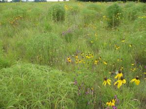
- Permanently protects natural resources on private land
- Restores natural hydrology and native vegetation
- Targets economically marginal, flood-prone, environmentally sensitive, or highly erodible lands
- Reduces soil erosion, phosphorus and nitrogen loading, and flooding
- Improves and connects important wildlife habitat
Information for landowners:
- Contact your local SWCD to learn more
- Conservation Easement Frequently Asked Questions
- Landowner Guide to Conservation Easements (pdf) 1/4/2014
- Policy and Purpose
The Reinvest in Minnesota (RIM) Resources Law of 1986, Minnesota Statutes, sections 103F.505 to 103F.531, and subsequent amendments, established the RIM conservation easement program.
The statute states the purpose of RIM is to restore certain marginal agricultural land and protect environmentally sensitive areas to:
(1) enhance soil and water quality;
(2) minimize damage to flood-prone areas;
(3) sequester carbon;
(4) support native plant, fish, and wildlife habitats; and
(5) establish perennial vegetation.The statute further states that it is state policy to encourage:
(1) restoration of wetlands and riparian lands;
(2) restoration and protection of marginal, highly erodible land, particularly land adjacent to public waters, drainage systems, wetlands, and locally designated priority waters; and
(3) protection of environmentally sensitive areas, including wellhead protection areas, grasslands, peatlands, shorelands, karst geology, and forest lands in priority areas.- Funding
BWSR's conservation easement programs have been and are currently funded by a variety of sources, including:
- Outdoor Heritage Fund
- Clean Water Fund
- Environmental and Natural Resources Trust Fund
- Bonding
- General Fund
- Federal Partnerships


- Eligibility
Both the landowner and the site must meet certain requirements, depending on the program, to be eligible for a RIM easement. A determination of eligibility should be made early in discussions with the landowner. Before proceeding with an application, refer to the RIM Eligibility page, as well as program specific guidance, to determine if the landowner and the land meet eligibility requirements.
- Tax Forfeit Lands
Below are guidelines for the implementation of county sale, exchange, or transfer of tax forfeit lands, as defined in MN Statutes Section 282.018, subd 2 and 103F.535.
State lands offered for sale, transfer or exchange that contain wetlands or nonforested marginal lands must be withdrawn from sale unless a restrictive covenant is placed on the deed that prevents these lands from being enrolled in a state-funded program that provides compensation to landowners for conservation of these lands.
Soil and Water Conservation Districts (SWCDs) may make wetland and nonforested marginal land determinations for their counties, when requested.
Steps in the process to determine the presence of wetlands and/or nonforested marginal lands and notifying prospective purchasers:
- The county with tax forfeit land to sell, exchange or transfer determines that it is saleable and not legally exempt by statute.
- For all non-exempt parcels, the county requests a determination of the existence of wetlands or marginal nonforested lands from the SWCD or county land commissioner on the parcel to be sold.
- The SWCD or county land commissioner completes the determination using the Notice To Prospective Purchasers/Owners Of State Land. This notice provides the required information to aid in the determination if a deed restriction is needed.
- The SWCD or county land commissioner returns the completed and signed notice to the county.
- The county includes the completed form in the file for each non-exempt land parcel to be sold.
- The county completes the list of sale parcels for Department of Natural Resources (DNR) approval.
- The county receives DNR approval.
- The county holds the sale of tax forfeit lands.
- For each parcel sold, the county submits a completed Department of Revenue (DoR) certification form.
- DoR completes the deed for the parcels sold that contains the deed restriction language.
- Scoring, Selection, and Funding Decisions
Every RIM program uses a scoresheet to evaluate the easement’s potential to meet the program goals and compared to other applications submitted. Scoresheets can be found on individual program pages linked from the Programs page. Scoring is only one piece of information used to make funding decisions. Extenuating circumstances may raise, lower, or eliminate an application, regardless of the score.
BWSR uses different methods of making funding decisions depending on the program. Go to the Programs page to find the application and funding schedule of each program.
Technical Committees
Technical committees are composed of the RIM Program Coordinator, SWCDs within the geographic range of the program, technical experts from other agencies and non-profits when appropriate. Technical committees are used for smaller programs and where limited geography keeps the committee from becoming unwieldy in terms of participants. The committees are program specific and usually meet 3-4 times a year to consider applications. SWCD staff present the proposed easement to the committee and stand for questions. Local knowledge such as threat, urgency, status of the landowner, SWCD workload (which can affect the ability to complete an easement in a timely manner), etc. are discussed and the score sheet is reviewed. Decisions are by consensus. Occasionally, when time is limited and a project would be very likely to be funded at the next technical committee, the process is conducted by email.
Batching
Batching is a process where there are hard quarterly deadlines for applications to be submitted and decisions are made by BWSR staff (although frequently with SWCD input). This method works well for state-wide and well-established programs. In particular statewide programs are not suited to the technical committee process becomes too unwieldy with potentially upwards of 80 SWCDs participating. Batching programs may require extensive information up front to help BWSR staff in the decision-making process. For example, RIM Wetlands has extensive requirements as part of the score sheet that provide important information. If there are questions about a given application RIM staff will reach out to the SWCD,
The Conservation Reserve Enhancement Program (MN CREP) is technically a batching program but is quite different. Go to the CREP Program Page for more information.
Rolling
Some more specialized BWSR-led programs accept applications on a rolling basis. Applications may be submitted upon completion and funding decisions are made on each individual application as needed.
- Payment Rates and Tax Considerations
Payment Rates
Depending upon program goals and guidance, RIM uses one of two methods to calculate payment rates.
- Township average value rates are established on an annual basis by BWSR using data from the MN Department of Revenue, as reported by local county assessors. Refer to the current township payment rates provided by BWSR for specific township payment rates in your area.
- Tax-assessed value rates are based upon a percent of the current tax assessed value of the land prorated to the number of acres in the offer. See the Tax-Assessed Value Conservation Easement Financial Worksheet (CEFW) Q&A for more information.
See the RIM Easement Payment Rate Determination Procedure (pdf) for more information.
Tax Considerations
- Tax Advice - Potential conservation easement grantors should refer only to their certified public accountant or other tax professional for tax advice.
- Capital Gains Tax - The conveyance of a perpetual conservation easement is a real estate transaction and may be subject to capital gains tax. All grantors should be aware that the full amount of the easement payment will be reported to the IRS corresponding to the year the payment is made. Where an easement has multiple grantors, a1099S Information Form will be included with the easement documents and must be filled out indicating how much (including zero) of the total easement payment will be paid to each individual (married couples are considered the same as individuals). Failure to fill out and submit the 1099S Information Forms will result in the easement payment being withheld.
- 1031 Exchanges - Like-kind exchanges under IRC Section 1031 may occur during the course of a conservation easement purchase. If a landowner is considering one, notify BWSR so that that is taken into consideration during the acquisition process.
- Property Taxes - The landowner is responsible for paying all taxes and any other levies and assessments that may be assessed on the enrolled land. Assessed values vary from county to county.
- Master Joint Powers Agreements, Work Orders, and Cost Reimbursements
BWSR contracts with SWCDs and other local units of government to implement RIM. To do this, BWSR and each SWCD complete a Master Joint Powers Agreement. This MJPA is an overarching agreement that allows an SWCD to enter into work order contracts for their services and request reimbursement for costs associated with RIM easements. The current MJPAs will be in place until January 2029.
If there have been changes to who may sign contracts at the SWCD, please help BWSR to reflect this information by notifying BWSR via an email to bwsr.rim@state.mn.us.
Go to Master Joint Powers Agreements, Cost Reimbursements, and Work Orders for more information.